
Destinations
Experiences
|
L A
D A T C O T O U R
S |
|
||||||||
| HOME | South America | Falkland Islands | Antarctica | Unique Destinations |
Unique Experiences |
Newsstand | ||||
| Paine Towers National Park |
|
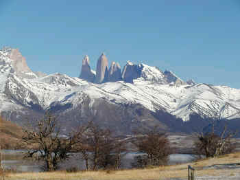
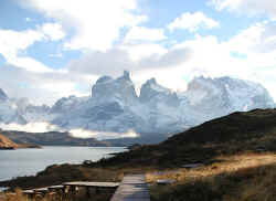
PARQUE NACIONAL TORRES DEL PAINE Without a doubt, Paine Towers is one of the most spectacular mountain areas on earth. In the center of the park is a granite massif from which rise the Torres (Towers) and the Cuernos (Horns) of Paine, oddly shaped peaks of over 2,600 meters. There are 15 peaks in the park above 2000 meters, the highest of which is Cerro Paine Grande. The valleys are filled with beautiful lakes and the enormous Campo de Hielo Sur icecap gives the park four main glaicers: Grey, Dickson, Zapata and Tyndall. Two other glaciers descend from the west side of the central massif. |
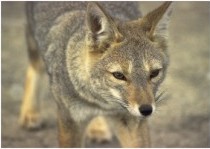 |
There is an abundance of wildlife in the park due to a mico-climate especially favorable to plants and wildlife. There are 105 species of birds including 18 species of waterfowl and 11 birds of prey. Particularly noteworthy are condors, which are quite common, black-necked swans, rheas, kelp geese, ibis, flamingos and autral parrots. There are also 25 species of mammals including guanacos, hares, foxes, huemules (a species of deer), pumas and skunk. Over 200 species of plants have been identified. |
| QUICK FACTS: GETTING THERE: It is located 400 KM (244 miles) north of Punta Arenas, a five hour drive via Puerto Natales (Punta Arenas-Puerto Natales 3 hours; Puerto Natales-Paine Towers 2 hours). AREA: 598,000 acres, with mountains, glaciers, rivers, lakes, waterfalls THE MOUNTAINS: Torres del Paine (9,000 ft) and Cuernos del Paine (6,300 ft) and 15 others more than 6,000 high |
|
| THE LAKES: Pehoe,
Nordenskjold, Sarmiento, Pingo, , Toro, Grey and Dickson THE LAGOONS: Verde, Azul, Amarga THE GLACIERS: Grey, Pingo, Tyndall, del Frances and Dickson ALTITUDE: Although there are mountains of
up to 9,000 feet tall, the planes of the park are only 138 feet above sea level |
| THE CLIMATE:
The park has a micro-climate. The short distance separating it from the ocean produces a mild climate. In the rainy season, rainfall never exceeds 85mm. A thin layer of snow may cover some areas of the park during winter. There are gusts of strong winds (up to 110 km/hr), coming from the west and primarily at the end of spring and beginning of summer. Winters tend to be calm, with moderately cold, clear days.
|
||||||||||||||||||||||||||||||||||||||||||||||||||||
WHERE TO STAY - LADATCO's Preferred properties Just outside Puerto Natales: Remota and The Singular Patagonia Just outside the park: Patagonia Camp, Tierra Patagonia and Awasi Patagonia In the park: Hotel Explora, Hosteria Las Torres, Hotel Rio Serrano
CROSSING TO ARGENTINA: |