
Destinations
Experiences
|
L A
D A T C O T O U R
S |
|
||||||||
| HOME | South America | Falkland Islands | Antarctica | Unique Destinations |
Unique Experiences |
Newsstand | ||||
|
Kuelap Fortress in the Clouds The Basics |
WHEN TO GO:
ONLY between June and October. Rains begin in November
and last through March-April, rendering many access roads and trails extremely muddy and
therefore almost unpassable.
GETTING THERE - to the
area of Kuelap:
While there is an airport in Cahchapoyas, service is not
reliable and therefore not an option for most visitors. Take a flight from Lima to
Chiclayo and then go overland from Chiclayo - a long but scenic day. While the drive
is only 404 kilometers (254 miles) it takes ALL day - around 8 or 9 hours depending on how
many stops you make for photography. Driving northeast from Chiclayo the first
hour is paved road. Then you hit the coastal mountain range and the climb up via
zig-zagging roads begins up to Porculla Pass (7034 feet high) - just 27 miles but taking
nearly 2 hours! Then it's down into the valley and then zig-zagging up the second
mountain range, even higher and more scenic until you once again zig-zag your way down to
the Utcubamba River Valley. The road is basically a gravel wide one lane, with
enough room to pass oncoming vehicles.
Don't be tempted to "make a circuit" and return via Celendin to Cajamarca UNLESS you thrive on narrow, gravel roads that cling to the side of the mountains, with solid rock on one side and sheer drops on the other! The first ascent takes you to the highest pass - Barro Negro at 12,073 high, then you plunge down hair-raising hairpins to Las Balsas at 3100 feet, cross the valley and start up again on another series of more gentle and friendly-user switchbacks and then down to Celendin.
Though going the opposite direction, in the September issue of National Geographic Magazine in the "Peru's Lost Tombs", author Peter Lerche describes the trip from Celendin to Leimbebamba area:
| "...the team boarded a minivan and held on
tight as out driver headed toward the mountains. It was a typical ride along unpaved
Peruvian roads, bucking up and down on rolling terrain - until the van came to the edge of
a vast, deep valley. "Now what?" asked Gordon. The driver hit the gas - gently - and the next several hours was spent creeping back and forth down a dirt switchback road. When the van finally bottom out, we'd descended 7,500 feet into the Maranon gorge. "Now what?" asked Gordon. The driver hit the gas - hard - and drove up the other side, this time 10,000 feet of virtually vertical switchbacks. A 12-hour day had yielded just 55 miles as the crow flies. |
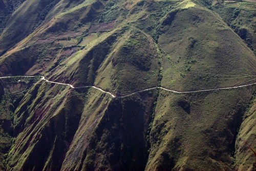
ONCE THERE - Getting to Kuelap:
The drive from the Utcubamba
Valley (Chachapoyas is another 45 minutes away from the valley) is from Tingo via a series
of switchbacks up to Nuevo Tingo and then snaking along one mountain to the end to cross
over to the next mountain, all the while climbing upwards. Think of it as a "u"
- you start on one side and end on the other, all the while climbing upwards. The views
are spectacular - of the mountain ridge where Kuelap is situated on the first part of the
journey and then of the road once you have crossed over. The drive takes about 3 hours
depending on the number of stops you make for photography.
Once you are at the parking lot, there is a well maintained wide path with railing and occasional bench to the end of the ruins - about a kilometer (6/10ths of a mile) of moderate up-hill walking. Then from the first encounter with the Fortress it is another kilometer along the walls to the entrance into the fortified city itself. Once inside you will walk from one end to the other - and then back again to exit via the same door you came through into the city - and then the length of the walls and the kilometer down hill to the parking area.
There are no facilities so be prepared to use the great outdoors - and to leave no trace behind.
WHERE TO STAY:
While there are facilities in Chachapoyas, staying there puts
another 45 minutes away from the valley, which is the starting point for any of the
visits. So better off to stay down in the valley. At the moment, Estancia
Chillo, at the edge of the tiny village El Chillo, is the best option. The service
is friendly, the accommodations comfortable (private baths; hot water as of September
2000) and the home cooking outstanding.
WHAT TO BRING WITH YOU:
Since the time to go is their winter, you will need to plan
to layer clothes - days can be very warm and sunny, with nights cool. Bring your hiking
boots - you'll be glad you did, especially if you encounter any muddy paths. Also be sure
to bring with you a hat with a brim or bill, protection from the sun and from insects.
And never forget the Kleenex and ziploc bags, essential for using the vast outdoors
as "the facilities".