
Destinations
Experiences
|
L A
D A T C O T O U R
S |
|
||||||||
| HOME | South America | Falkland Islands | Antarctica | Unique Destinations |
Unique Experiences |
Newsstand | ||||
 |
Easter Island Mysterious and Enigmatic |
|
|
|
|
 |
ABOUT EASTER ISLAND:
Easter Island is the singularly most isolated island on earth, with its nearest neighbors more than 1,400 miles away across the open ocean. Chile is 2,400 miles to the east of Easter Island.
It is a small rectangular island measuring roughly 14 miles long by seven miles wide. Each of its three corners boasts a volcanic cone. It's origin is said to have taken place some two million years ago when the first volcano, later to be known as Poike, erupted, followed by its siblings Rano Kau and Maunga Terevaka. With in the triangle they form, there are rolling hills and a few flat pastures.
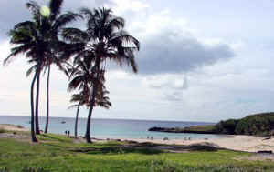
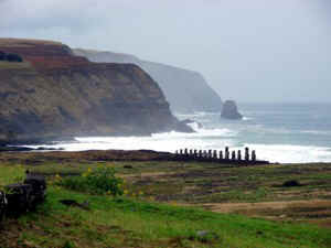
The coastline is abrupt and rocky with many cliffs and no sheltered coves. There are only three beaches, sporting white-pink coral sand: Anakena, Ovahe and La Perouse. A short distance offshore are several rocky islets.
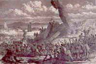
There are two contending theories on how Easter Island, or Rapa Nui as it is also called, was colonized. One is that it was colonized between the fourth and eighth centuries AD by travelers from Polynesia. Another suggests they came from South America because of similarity in construction between that of the Andes in Peru and on Easter Island.
Presumably they arrived by accident, but certainly they remained isolated for centuries.
They developed a complex culture, made up of a series of groups with a so-called single-line kinship and was headed by a king believed to descend directly from the gods of creation.
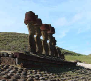
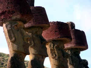
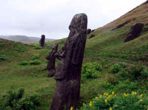
Each clan - "mata" - occupied an inland territory and a strip of coast where the clan's religious, political and social center was located, together with the ceremonial alter - "ahu" - where deified ancestors were worshiped. These were represented by stone statues, the "moai".
|
One of the legends claims that it took 30,000
man-days to carve, transport and erect a single statue. While the moai average 12 to 25
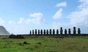
feet tall, the tallest is 32 feet tall and weighs 50 tons. There are 240 ahu, honoring the spirits of deceased relatives, along the coastline but mysteriously enough the moai associated with them face inland, with their backs to the sea. There is an excellent museum on the island which should not be missed. |
MAIN SITES TO VISIT INCLUDE:
AHU AKIVI with seven moai and two small stone columns which during the summer solstice (Dec 21) has the sun wedged exactly between the two of them, offering some evidence of the islanders' mastery of astronomy. This site was restored in 1960-1961. Legend says the moai represent the seven sons of a Maori sorcerer sent to search for Rapa Nui - a home for king Hotu Matua. The moai face the spot where the first inhabitants were supposed to have come ashore. Nearby are some caves and Ahu Tepeu with stonework that rivals the Incas.
VINAPU with the ruins of two ahu, one of which bears a striking resemblance to Machu Picchu's stone masonry work. The moai which used to sit atop this structure have been toppled, one of them lying semi-buried and staring to the heavens.
RANO RARAKU is the volcano containing the quarry where nearly all the moai existing were sculpted. Here are over 300 moai in various stages of completion including one measuring 21 meters in height, the equivalent of a seven story building, and weighing approximately 250 to 300 tons. There are also 8 perfectly round holes which remain a mystery.
ANAKENA with two restored ahu and the island's most beautiful beach. This area is thought to have been a residential center of ancient rulers. Not far away is another of the island's beaches, Ovahe.
ANA KAI TANGATA cave with birdman paintings on the ceiling
ORONGO ceremonial village with several dwellings built out of stone slabs, exceptional commanding scenic vistas and concentration of petroglyphs including those of Tangata Manu, the birdman; Make Make, the god that created him and Komari, the fertility symbol.
AHU TONGARIKI with the archaeological remains scattered dozens of meters away from their original site during to a tidal wave in 1960.
TAHAI ceremonial center with three ahu: Kote Riku, Tahai, Vai Uri. Only Kote Riku has had its one moai restored.