
Destinations
Experiences
|
L A
D A T C O T O U R
S |
|
||||||||
| HOME | South America | Falkland Islands | Antarctica | Unique Destinations |
Unique Experiences |
Newsstand | ||||
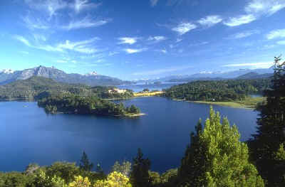 Peninsuala Llao Llao |
Bariloche,
Argentina Click here for Argentina to Chile Lake Crossing schedule Click here for map Bariloche-San Martin de los Andes
Golfing |
This picturesque town on the southern shore of Lake Nahuel Huapi in the National Park of the same name, is located in one of the most beautiful regions of the country.
Amidst grandiose snow capped mountains, crystal clear waters and dense forest of cypress and coihue trees, it is known as the Switzerland of Argentina as even the architecture is reminiscent of Europe. The landscape however, is on a much larger scale in practically virgin land, unexplored and unspoilt, a really wild and beautiful corner of the world where nature can be appreciated at her best.
Founded in 1903, at an altitude of 770m. with some 100.000 inhabitants, Bariloche is the starting point for many scenic excursions through the lake district and has the oldest and best known Argentine Ski Center Cerro Catedral. Lake Nahuel Huapi has an irregular shore of 557 km and a maximum depth of 454m. It is connected to network of lakes and streams fed by melting ice, teeming with trout and salmon, a real paradise for fishermen.
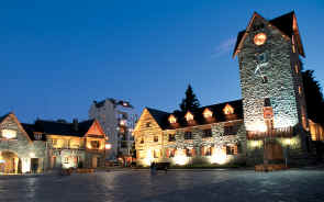 Civic Center in the heart of town |
SOME IMPORTANT POINTS
- IN BARILOCHE: The "Centro Cívico" Inaugurated on March 17, 1940, this was Argentina's first civic center. Designed by architect E. de Estrada, it was built from "ciprés" and "alerce" wood and stone quarried from Carbón mountain. A monument to Julio A. Roca stands in the center of the square. The Centro Cívico was declared a National Monument in 1987. The square is surrounded by buildings hosting the Police Station, the ex-post office and ex-customs offices (now an exhibition salon), the Offices of the Municipal Secretariat of Tourism, the Town Hall, Museum and Sarmiento Library. There is a large clock in the Town Hall tower. When it strikes 12 noon and 6 p.m., 4 figures that represent the area appear: an Indian, a missionary, a "conquistador" and a laborer. (see detailed information). Bariloche Cathedral Built in 1946, under the name Nuestra Seńora del Nahuel Huapi -Our Lady of Nahuel Huapi- it belongs to the National Parks Administration and has been declared a National Historical Monument. The Bariloche diocese was created in 1993. Its bishop is Monseńor Rubén Frassia. Every Christmas a concert is given at the cathedral by the "Coro de Nińos y Jóvenes Cantores de Bariloche" -Bariloche Children and Young People's Choir- together with other choirs and local musicians. Patagonia Museum "Francisco P. Moreno" Inaugurated by Parques Nacionales in 1940, the museum is located at the east end of the Centro Cívico. It was named after Francisco P. Moreno, who explored the Andes and Patagonian rivers, and donated to the government the lands which were to become Argentina's first National Park (see information on Nahuel Huapi National Park). There are various sections, including natural history, prehistory, ethnography and regional history. There is also a Temporary Exhibition room, a public library containing some 3000 books, a Design and Research Department, a collection storeroom and a theater. The museum is administrated by the National Parks superintendence and supported by Asociación Amigos del Museo -Friends of the Museum Association- which has existed since 1985. |
|
SOME IMPORTANT POINTS
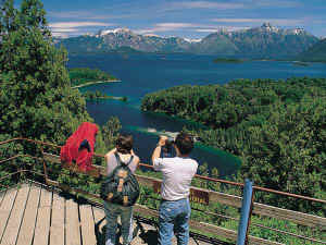
- AROUND BARILOCHE: The Cerro Campanario provides possibly the best lookout point in the region, with exceptional views of Nahuel Huapi and Perito Moreno lakes, as well as the ravishing beauty of the Llao Llao Peninsula and the peaks surrounding it. The lookout point is accessed by a 7-minute cable car ride located 17km (11 miles) outside Bariloche on the road to Llao Llao. There's also a restaurant with panoramic views. The Cerro Campanario is along a popular, 60km (37-mile) drive around the Llao Llao Peninsula, commonly known as the Circuito Chico. This drive offers spectacular views of Nahuel Huapi and Perito Moreno lakes and the snowcapped peaks of Cerro Otway and Catedral that tower over them. The drive begins 18km (11 miles) from Bariloche on Avenida Bustillo, which changes into Route 237, loops around the peninsula as Route 77 and meets back at Route 237 and eventually Bustillo, all the while meandering through dense forest and picturesque bays with outstanding lookout points. Visitors will find parrilla (grill) and fondue-style restaurants along the way, as well as the world-renowned Llao Llao Hotel & Resort. Stop by the visitor center to pick up a detailed Circuito Chico map highlighting restaurants and shops along the way. Again, most tour operators offer this excursion.
Nahuel Huapi is Argentina's oldest and most
popular national park, offering just about everything for any interest or physical level.
The park surrounds the city of Bariloche, and its headquarters are downtown in the Civic
Center. The park's main feature is the 3,500m (11,480-ft.) extinct volcano Tronador
(Thunderer), named for the rumbling produced by ice falling from the mountain's peak. But
the park is also known for the glacial-formed Lake Nahuel Huapi and its lovely forested
peninsulas and waterways that often provoke comparison to the channels of southern
Patagonia or the fjords of Norway. During summertime visitors can take part in day hikes
or backpacking trips along one of the park's several trails or boat out to one of the
lake's islands. |
CIRCUITO CHICO AND PANORAMIC POINT : A scenic 50km drive skirting Lake Nahuel Huapi as far as Puerto Pańuelo and the Llao Llao peninsula. Leaving this lake behind, the road climbs through a forest of coihue trees, a native evergreen, offering views of the Andean peaks, Tronador (Thunderer) being the highest (3554m). The road then winds along Lake Moreno to a panoramic point which offers a breathtaking view of Lakes Moreno and Nahuel Huapi, Victoria Island and the Andes in all their splendor. We suggest an optional stop at Cerro Campanario to take the chair-lift to the summit for a spectacular view.
CATHEDRAL MOUNTAIN : This 2388 mountain is 20 km from Bariloche and is one of the leading Latin American ski resorts with 67 km of slopes. It owes its name to the remarkable rocky formation at the summit with limestone crests and rock pinnacles, just like the spires of a cathedral. The summit can be reached by cable car or chair lift and offers a magnificent view of the Andes, its peaks, blue lakes, valleys and the town of San Carlos de Bariloche. VICTORIA ISLAND AND ARRAYANES WOOD : Full day lake excursion. Departure from hotel along Nahuel Huapi Lake coast up to Puerto Pańuelo. Boarding a boat we cruise the Nahuel Huapi Lake up to Quetrihue peninsula for a walk in a forest of arrayanes (myrtles) unique in the world for the purity of the species. This bush, which grows as a tree here, is cynnamon coloured and inspired Walt Disney to make his famous picture Bamby. After a short walk continue cruissing to Victoria Island. This 31 km island has steep cliffs along its shore and a temperate microclimate, favourable for the growth of a dense and picturesque vegetation. Late afternoon return to Puerto Pańuelo. PUERTO BLEST & CASCADA LOS CANTAROS: Full day excursion. Departure from hotel to Puerto Pańuelo, cruise along the Blest arm of the Nahuel Huapi Lake until its end where Puerto Blest is located. The landscape along the Blest arm is similar to the norwegian fiords of the far Tierra del Fuego channels. The Puerto Blest zone has an exuberant forest due to its climate which is extremely humid. From Puerto Blest the catamaran makes the crossing to Cascada Los Cantaros where pax disembark and go up a wooden stair bordering the torrente Los Cantaros till an altitude of approximately 600 mts. From this point they can admire several falls and cascades of a remarkable beauty. After going down embark to return to Bariloche.