

Destinations
Experiences
|
L A
D A T C O T O U R
S |
|
||||||||
| HOME | South America | Falkland Islands | Antarctica | Unique Destinations |
Unique Experiences |
Newsstand | ||||
 |
Choquequirao Peru |
 |
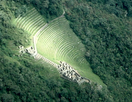
ABOUT CHOQUEQUIRAO - gathered from multiple sources and edited by LADATCO:Choquequirao is considered the second Machu Picchu, and has been called “Machu Picchu’s sacred sister”, because of the striking similarities of design and ceremonial architecture.
Choquequirao sits in the saddle of a high Andean ridge, 3000m./10,000 ft. above sea level and 1,500m./5,000 ft. above the roaring waters of the Apurimac River. Ringed by spectacular snow-capped peaks and flanked by plunging, thickly forested slopes, the city is an inspiring example of an elite Inca ceremonial center, dedicated to the worship of the mountain gods, the river and the elements of nature.
It's history remains a matter of speculation. The building of Chocquequirao is the work of Inca Pachacutec successors Tupac Inca Yupanqui (1 471-1 493) and Wayna Capac (1 493-1 527). Household and ceremonial pottery has been found here that bears both the classic Cusco style and also from other populations who came to live here to build and permanently populate the area. Most likely, they were experienced farmers who knew how to build and use farming terraces in high Amazon forest areas. Located at 3 050 masl on the border with department of Apurímac, the Choquequirao archeological compound was not built to be a place of easy access. Reaching it demands two days of disciplined march, largely compensated by the beauty of the landscape that wayfarers cross from the beginning of their expedition.
The Manco Inca dynasty resisted the Spanish conquerors during 40 years (1 536 to 1 572) from this fortress in the Vilcabamaba area. The Spanish conquerors were never able to expel them from it.
Choquequirao was probably one of the entrance check point to the Vilcabamba region, and also an administrative hub serving political, social and economic functions. Its urban design has followed the symbolic patterns of the imperial capital, with ritual places dedicated to the Sun (Inti) and the ancestors, to the earth, water and other divinities, with mansions for administrators and houses for artisans, warehouses, large dormitories or kallankas and farming terraces belonging to the Inca or the local people. Spreading over 700 meters, the ceremonial area drops as much as 65 meters from the elevated areas to the main square.
One speculation of its origins holds that it was a royal estate built for the emperor Topa Inca, perhaps in an attempt to rival his father Pachacuti’s spectacular domain at Machu Picchu.
For centuries Choquequirao lay shrouded in obscurity, protected by its remoteness. Unlike Machu Picchu, people knew it was there – it was first mentioned in a Spanish document of 1710, later visited by various explorers and treasure hunters, and roughly surveyed in the 19th century by the French consul in Lima, Leonce Angrand. Finally, in 1909, the indefatigable U.S. explorer Hiram Bingham –the future scientific discoverer of Machu Picchu -- explored and mapped the site.
Approximately 40% of the Choquequirao Inca ceremonial center has been cleared of vegetation. The remaining area is formed by a complex terrace system built on extremely steep slopes. A very impressive stairway of 180 terraces has been recently spotted. It descends from one of the ceremonial center flanks and reaches the river open to swimming.
GETTING TO CHOQUEQUIRAO:
- TREKKING:
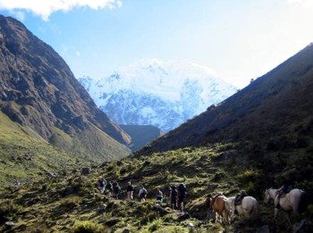
Travel some 145 kilometers of paved road and 10 kilometers of dirt road from Cuzco to Cachora (2300 masl) where the trail begins. Cross the Apurimac River via a modern footbridge for . The journey is as awe-inspiring as ever, taking us through an astounding range of ecological zones, from Andean farming valleys, descending through a hot and arid canyon environment featuring kapok trees, cactus and agaves, and climbing again to a region of lush cloud forest, beneath the dizzying snowcaps of the Cordillera Vilcabamba. At the moment, the only way out is to make the return trek to Cachora and road back to Cuzco or continue trekking to Machu Picchu, and return by train to Cuzco.- HELICOPTER:
A helicopter fly-over of Choquequirao takes about 2 1/2 hours from Cuzco. If an actual visit to the ruins is desired, the walk from the landing site to the ruins is uphill and takes about an hour, so combined with a walk up, walk down and two hour visit to the ruins, the entire day would be around 6 to 7 hours, and the charge for the helicopter is by the hour, making this a very expensive proposition. This is also subject to weather conditions.WEATHER:
The Andean weather can be unpredictable, despite the sharp divide between dry and wet seasons. The dry season runs from May to October or November; the rainy season goes from December through April. Nevertheless, Choquequirao lies in the forested fringes of the Amazon basin, where showers can occur at any time of year. Therefore, even in the "dry" season, your daypack should always include full rain gear (both jacket AND trousers).
Daytime temperatures can vary greatly, with daytime highs ranging from 10şC/50şF to 32şC/90şF and nightime lows ranging from 10şC/50şF to a cold 4şC/40şF, though seldom much lower. The floor of the Apurimac Canyon gets very hot during the day. Bring your swimsuit for a delicious dip in the river.